Cyclonic circulation over Haryana was trigger for dust storm: Experts
May 03, 2018 19:49
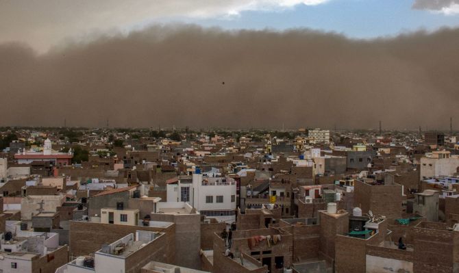
A cyclonic circulation over Haryana was the trigger for the deadly dust storm that swept parts of Rajasthan and Uttar Pradesh, weather experts said today, estimating that the wind speed during the storm may have gone up to 100 kilometres per hour.
The winds were so violent that a number of houses collapsed and electricity poles and trees got uprooted, as the severe dust storm swept parts of these states.
The phenomenon was restricted to these two states, largely because of external and domestic reasons, experts said.
There were primarily four reasons that lead to the thunderstorm -- excessive heating, availability of moisture, instability in atmosphere and a trigger for the storm, India Meteorological Department Additional Director General Mritunjay Mohapatra said.
"The north Indian plains have been witnessing temperatures of over 40 degree Celsius. There were two sources of moisture --a western disturbance over north Pakistan and adjoining Jammu and Kashmir and easterly winds from the Bay of Bengal," Mohaptara said.
The cold winds from the western disturbance was making atmosphere unstable.
"The trigger was a cyclonic circulation over Haryana," Mohapatra said.
This led to the formation of two cloud patches, said Mahesh Palawat, Vice President (Meteorology and Climate Change) of Skymet, a private firm that provides weather forecast
One patch moved to north of Delhi, while another patch moved over the Alwar, Agra, and Dholpur belt, which was more deadly.
Mohapatra said it was difficult to record the wind speed as the phenomenon was restricted to only small patches. In Delhi, where a milder version of the dust storm and thunderstorm struck, the wind speed was recorded as 69 kmph.
However, Palawat estimated that the wind speed would have been more than 100 kmph. -- PTI
TOP STORIES


 © 2024 Rediff.com - Investor Information - Advertise with us - Disclaimer - Privacy Policy - Feedback - About us - Terms of use - Grievances