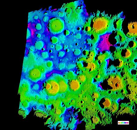
 Astronomers have created a new lunar topography map with the highest resolution of the moon's rugged south polar region, which they claim provides new data on some of the Earth's natural satellite's dark craters.
A team at NASA's Jet Propulsion Laboratory, Pasadena, in California created the map after collecting the data using the Deep Space Network's Goldstone Solar System Radar located in the Mojave Desert.
According to them, the map will help Lunar Crater Observation and Sensing Satellite mission planners as they target for an encounter with a permanently dark crater near the lunar South Pole.
"Since the beginning of time, these lunar craters have been invisible to humanity. Now we can see detailed topography inside these craters down to 40 meters (132 feet) per pixel, with height accuracy of better than 5 meters (16 feet)," said Barbara Wilson, who led the team.
In fact, the astronomers targeted moon's south polar region using Goldstone's 230-foot radar dish. The antenna, three-quarters the size of a football field, sent a 500-kilowatt-strong, 90-minute-long radar stream 373,046 kilometres to the moon, the US space agency said.
Signals were reflected back from the rough-hewn lunar terrain and detected by two of Goldstone's 34-meter (112-foot) antennas on Earth. The roundtrip time, from the antenna to the moon and back, was about two-and-a-half seconds.
The scientists compared their data with laser altimeter data recently released by the Japanese Aerospace Exploration Agency's Kaguya mission to position and orient the radar images and maps.
The new map provides contiguous topographic detail over a region approximately 500 kilometres by 400 kilometres.